Severe weather possible through this weekend
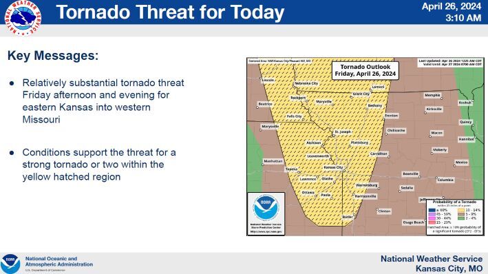
NATIONAL WEATHER SERVICE
4- 26 Weather – Tornado Threat Friday.psd
MARYVILLE, Mo. — Nodaway County Emergency Management Director Christy Forney, sent out a warning Friday morning about an enhanced risk for severe weather starting today and continuing through the weekend.
“The NWS has put northeastern KS and northwestern MO in an enhanced risk for hail, high winds, and tornadoes,” she wrote in an email. “Pay close attention to watches and warnings.”
Forney explained that a watch means weather conditions are favorable for the event to occur, while a warning means the event is imminent and take shelter immediately.
According to the NWS’s hazardous weather warning, the increased possibility for severe weather begins Friday afternoon and continues through Saturday and Sunday. An additional 1 to 3 inches of rain is also possible, which may lead to flash and river flooding.
“Review your safety plan and utilize multiple methods for monitoring the weather,” Forney said, in a statement. “Stay safe.”
Update
Around 4 p.m. Nodaway County Emergency Management Director Christy Forney announced that Nodaway County was in a tornado watch until 9 p.m. on Friday.
According to an email, the Maryville R-II School district has agreed to open the FEMA approved gym as a storm shelter.
Located at Maryville High School, 1503 S. Munn Ave., the storm shelter will be open if storm spotters are activated and/or the NWS issues a tornado warning for the city of Maryville.
“I will keep our local media outlets updated of the situation,” Forney said. “Please be mindful and respectful of the space. Remain weather aware throughout the weekend and stay safe.”
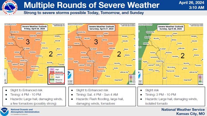
NATIONAL WEATHER SERVICE
4-26 Weather – Weekend.psd