
High temps bringing triple-digit heat indexes
TOM PINNEY/DAILY FORUM
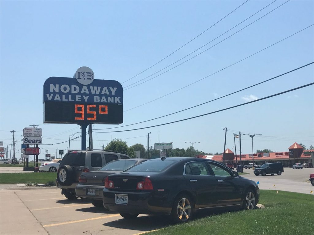
The clock board at the Nodaway Valley Bank on South Main Street shows a sweltering heat of 95 degrees near 2 p.m. Monday afternoon. Nodaway County and surrounding areas are under a heat advisory until Wednesday evening, with high temperatures and heat indexes in the forecast through the weekend.
It’s the beginning of summer, and northwestern Missouri is in for a heat wave expected to last at least through next week.
The National Weather Service has issued a Heat Advisory through this Wednesday at 7 p.m., which Joey Welsh, staff meteorologist at the National Weather Service office in Pleasant Hill, said is issued for more than just high temperatures.
“Heat advisories are issued when the heat index is forecast at 105 degrees or greater, or if a heat event poses a health risk for the community,” Walsh said. “Here, the air temperatures will be in the low- to mid-90s through Wednesday, and we’re expecting to see heat index values in that 105 range all three days.
“With multi-day highs in that range and overnight lows in the mid-70s, we’re concerned about heat-related illnesses, which is why we issue the advisory.”
The key to the advisory is the heat index, which is why, even though highs are supposed to remain in the low- to mid-90s through the end of the week, the advisory only extends through Wednesday. Walsh explained that the index would likely die down later in the week.
“The heat index depends heavily on air temperatures and relative humidity,” Walsh said. “It’s a measure of what temperature your body responds to as far as what it feels like outside, and when dew points are increased, we tend to lose our body’s natural cooling effects. Our dew points now are in the lower 70s, and they’ll more or less continue to be in that range in the advisory period.
“At this time, it looks like Thursday will still be warm, but the dew point will steadily improve, meaning that the heat index will stay under the 105 range. It’ll still be warm, but with lower heat indexes, it won’t be as bad.”
That means warm and humid temperatures for the Nodaway County Fair which runs Thursday through Saturday. Most of the activities Thursday and Friday will be in the afternoon and evening, but Saturday is an all-day affair for some.
As such, Nodaway County Health Department administrator Tom Patterson said there were several precautions to take, not only for the fair, but for the advisory.
“Spend time inside if you can, and avoid being outside during the hot part of the day,” Patterson said. “There are some things that you can do to keep your home cool as well, such as not baking during the day, taking cool showers and baths, using fans to keep air moving, and drinking plenty of water while avoiding drinks with caffeine and high sugar content and alcoholic drinks.
“It’s also important during heat events like this to be conscious of other people that may be susceptible to heat-related illnesses. Check on elderly or sick neighbors to make sure they’re okay, and be sure that your children are getting enough fluids and not getting overheated.”
Patterson also advised wearing sunscreen and loose, lightweight and light colored clothing and noted that people should not overdo it in the heat, especially if you aren’t used to it, to prevent overheating. Hats and sunglasses also help keeping the sun off.
Patterson said there were two specific heat-related illnesses to watch out for — heat exhaustion and heat stroke.
“With heat exhaustion, just get into a cool place, lie down, elevate your feet, and use a cool and wet cloth on the forehead, wrists, and arms to cool down,” Patterson said. “It also helps to sip cool beverages, like water, and if you don’t feel better, consider seeking medical assistance.
“Heat exhaustion can lead to heat stroke, which is much worse. Call 911 and move the person to a cool place, lie them down with feet elevated, but don’t give them fluids as that will make them sick.”
Heat exhaustion, according to a release from the Nodaway County Health Department, shows symptoms such as heavy sweating, a fast and weak pulse, tiredness or weakness, paleness, dizziness or fainting, chills, muscle cramps, and nausea or vomiting. Heat stroke victims will show an extremely high body temperature of 103 degrees or higher, confusion, tingling sensations, dizziness, nausea, and convulsions, but no sweating.
Patterson said cooling centers would be available through the summer, including the Maryville Public Library, the Nodaway County Health Center, and the Nodaway County Senior Citizens Center, where people can go in and sit in air conditioning and get water. A full list of cooling centers through Missouri can be found at https://ogi.oa.mo.gov/DHSS/coolingCenter/index.html.
The heat wave comes on the heels of a National Oceanic and Atmospheric Administration (NOAA) report 2017 was the warmest January to June period on record in the contiguous United States. Welsh said that wasn’t surprising.
“We have noticed above-normal temperatures throughout much of the summer thus far, Walsh said. “The Kansas City area also recorded less than five inches of snow in the winter, which is approximately 10 inches below the climatological winter average, and it was warmer than usual.
“This (report) is on track with what we experienced here. This doesn’t necessarily equate to seasonal trends, though, and we’re keeping an eye on the effects of the El Nino to gauge the effect it will have on the winter.”