Severe storm pummels Nodaway County

KAITY HOLTMAN/DAILY FORUM
Straight-line winds Monday evening uprooted a shed, dismantled a hoop structure, and damaged other farm buildings along Route J south of Conception.
“We were lucky,” said Nodaway County Emergency Management Director Christy Forney on Wednesday — the morning after a Monday-evening storm produced one and possibly two tornadoes.
Forney said a twister confirmed by North Nodaway Fire and Rescue personnel hit the ground around 6:30 p.m. approximately two miles northeast of Skidmore near Highway 113.
A second funnel cloud reportedly touched down about the same time two miles southwest of Maryville, but Forney said she lacked official confirmation.
A severe thunderstorm warning followed moments later by a tornado warning for the Maryville area were issued shortly after 6 p.m., and the city’s storm sirens were activated at 6:15.
Despite the heavy weather, damage across the county was limited to a few farm buildings. There were apparently no injuries or fatalities.
Forney said it took the storm, which was accompanied by rain, hail, and high-velocity straight-line winds, about 45 minutes to roar through the county from west to east. Damage included a shed near Ravenwood, a pole barn east of Barnard containing at least one vehicle, and several farm buildings along Route J south of Conception.
While the lights stayed on for most Maryville residents, several homes reportedly lost power in Stanberry 25 miles to the east in Gentry County.
Pea-sized hail fell across much of the county, and Forney said golf ball-sized hail was reported in the Arkoe-Barnard area.
In Maryville, people caught away from home when the storm sirens sounded scurried to take shelter. Employees and customers at the Hy-Vee supermarket sought protection in one of the store’s large, walk-in coolers.
Store Director Travis Buysse said the coolers, which lack windows, are designated for use as shelters under store policy.
Meanwhile, less than a mile to the west at Maryville High School, about 250 people hunkered down in a still-uncompleted practice gymnasium, which was partially funded through a grant from the Federal Emergency Management Agency and is specifically designed to serve as a severe-weather shelter.
Principal Thom Alvarez said Wednesday those on campus when the storm hit included a large group of eighth graders on hand to tour the high school during the annual MHS Showcase, an annual spring term orientation event for next year’s freshman class.
Those sheltering in the FEMA gym also included MHS students on hand to serve as tour guides and people taking evening classes at Northwest Technical School.
Alvarez said most of the eighth graders were seated in the Schneider Performing Arts Center waiting to view a PowerPoint presentation when school officials started receiving severe-weather alerts via text messages and other media.
The teens were immediately evacuated to the new gym without incident, he said, and the remainder of the showcase was cancelled.
Ironically the storm arrived on the second day of Missouri Severe Weather Awareness Week, which continues through March 11.
The week included a statewide tornado drill on Tuesday organized by the National Weather Service and the State Emergency Management Agency and designed to test NWS’ emergency warning systems.
As things turned out the systems were indeed tested, albeit during an event that was anything but a drill.
Elsewhere across the region, tornadoes, hail, and high winds damaged nearly 500 buildings and injured a dozen people in Oak Grove, a city of 8,000 people located east of Kansas City near the Jackson-Lafayette county line.
According to the Associated Press, 483 homes in Oak Grove sustained some type of damage along with 10 to 12 commercial buildings.
Twelve people were treated by emergency responders, and three of them were taken to hospitals with non-life-threatening injuries.
Oak Grove Mayor Jeremy Martin praised the work of emergency crews, and said it was remarkable there were no deaths.
“It looks like the injuries are minimal so, based on some of the damage I’ve seen, it’s rather amazing,” Martin said.
The Storm Prediction Center in Norman, Oklahoma, received reports of more than 30 tornadoes in Kansas, Missouri, Iowa, and Illinois late Monday and early Tuesday. Powerful winds extended as far south as the Ozark Mountains in Arkansas, where a post office and church were damaged, and as far north as Wisconsin, where trees were downed.
Dan Hawblitzel, a National Weather Service meteorologist based in Pleasant Hill, said other corridors of significant damage included Smithville north of Kansas City and the Kansas suburbs of Leawood and Olathe.
There were no immediate reports of fatalities.
“It played out as we expected — several tornadoes and a lot of wind damage,” Hawblitzel said. “It’s certainly sad to see and hear about the homes destroyed.”
The late-winter storms spawned warnings from the Southern Plains to the Upper Midwest. Baseball-sized hail was reported in parts of Missouri, while hurricane-force winds were reported in parts of Iowa.
The Associated Press contributed to this story.
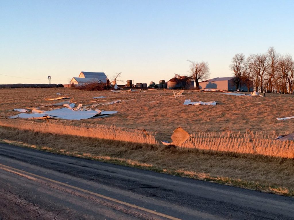
KAITY HOLTMAN/DAILY FORUM
Wind-blown debris litters a field early Tuesday near Conception. Monday’s evening’s late-winter storm brought hail, rain, and high-speed winds to Nodaway County and produced at least one tornado, which hit the ground around 6:30 p.m. about two miles northeast of Skidmore near Highway 113. A second twister may have touched down about the same southwest of Maryville.