Nodaway ambulance district moving to e-maps
TONY BROWN/DAILY FORUM
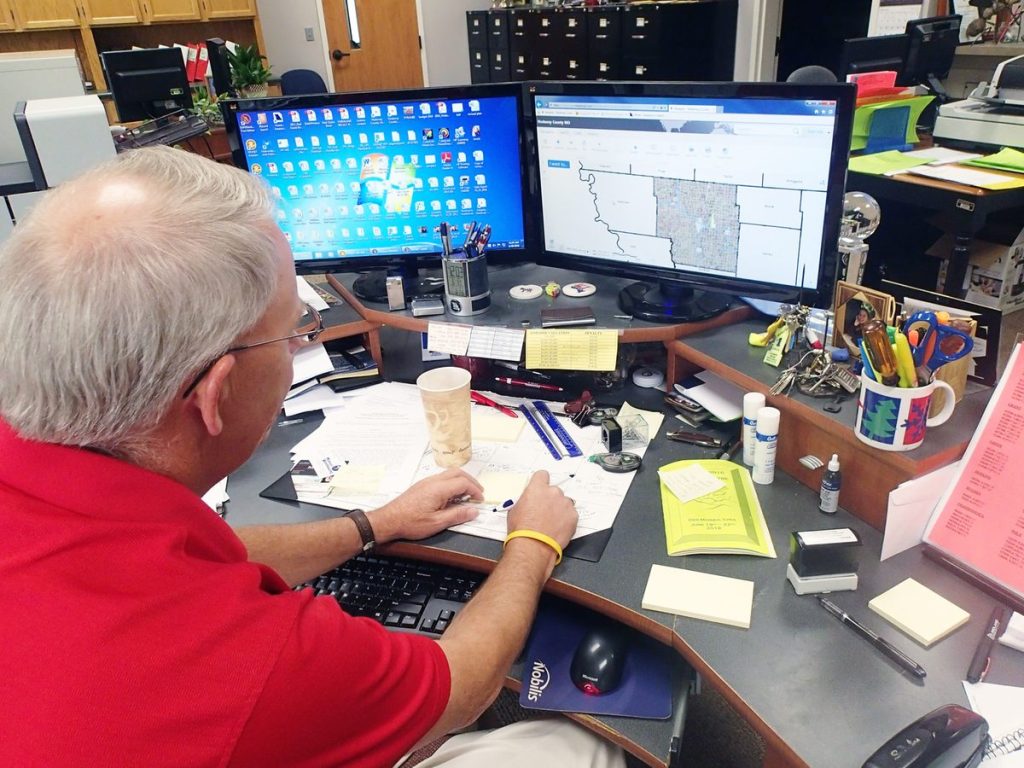
Nodaway County Assessor Rex Wallace views a map of Nodaway County using the Integrity GIS mapping system soon to be installed via roving Wi-Fi in the county’s ambulance fleet. Wallace described Integrity, which is provided through Midland GIS Solutions, as a “state of the art” system that is constantly updated to reflect new construction, address changes, and other data, including whether rural roads consist of gravel or dirt.
An error on a paper map that caused a delayed response time by a Nodaway County Ambulance District crew has led to a decision by the district’s board to acquire an advanced electronic mapping platform through a local geographic information systems company.
Nodaway County Assessor Rex Wallace, who also serves as the county’s 911 administrator, said the plat map book long used by ambulance crews, and which the district purchases from an insurance company, plotted a north county residence near Wilcox in the wrong spot.
The error prevented the ambulance from reaching its destination by nearly 40 minutes, at least double the normal response time.
As things turned out, Wallace said, the delayed arrival resulted in more aggravation than harm. But given the nature of emergency calls, things could easily have gone the other way.
The miscue resulted in a meeting last month between the ambulance board, Wallace, Nodaway County Sheriff Darren White, and Ryan Schieber, a senior GIS specialist with Midland GIS Solutions of Maryville.
While it might seem surprising that Nodaway ambulance crews still usually rely on paper maps rather than Google or some other Internet-based system, White said Thursday that in a large, rural county like this one such technology can be unreliable with regard to both access and content.
Nevertheless, after the recent delayed-response incident, the sheriff said all parties involved quickly decided the time had come for a change.
Following a presentation by Schieber, the ambulance board unanimously voted to acquire a Midland-supplied computer mapping system known as Integrity, which is the same platform used by the assessor’s office.
The county’s dispatch center at the jail, which relays 911 calls to the ambulance headquarters on the south end of town, uses a similar online mapping product marketed by another supplier, which White said allows for smoother communication between 911 stations in surrounding counties.
County patrol cars have electronic mapping capability as well and use the Integrity platform. However, White said, the cars don’t have roving Internet — or Wi-Fi — so map updates are not continuous.
That won’t be the case for the county’s ambulance fleet, which was equipped with Wi-Fi, short for “wireless fidelity,” early this year.
Wallace, who said his office employs Integrity “constantly” to keep track of land ownership, new construction, address changes, and other data, described the system as providing access to layered, searchable maps and other data on any computer or mobile device.
He said Integrity is frequently updated, sometimes on a daily basis, and reflects the most recent changes for address numbers and structure locations, including houses, farm buildings, and businesses.
A new feature being added with the ambulance district in mind, Wallace said, will tell crews whether rural county roads are gravel or dirt, which in this part of the country can be an important distinction after a heavy rain.
Bill Florea, the ambulance district’s director of operations, said Thursday that, in addition to Wi-Fi, laptops have been installed in four of the district’s six ambulances, and that the remaining two vehicles, which are used less often, are to be equipped with iPads or some other tablet device.
Wallace said initial cost to the district for the Integrity system is $5,000. Of that amount, $2,000 will go for software and $3,000 for detailed emergency response map books that combine Integrity data with printed aerial images.
In addition, Wallace is supplying the district with official county plat books for each ambulance at no charge. The books, which normally cost $25 each, replace the former insurance company publications, which Wallace said are routinely produced using two-year-old data.
County books, on the other hand, are updated annually.
While the move to electronic mapping in county ambulances may be coming late in the day, White said there has been little finger-pointing among the various officials involved about who should have done what when.
Instead, he said, the ambulance district board realized there was a problem and acted speedily to solve it.
“The board was very receptive,” White said. “They made up their minds right then that it was something we need to do, and I think it’s good for all of us.”
Wallace and Florea said implementation of the new system, including ambulance crew training, should be complete sometime this month.