
Heavy rainfall to come to Maryville
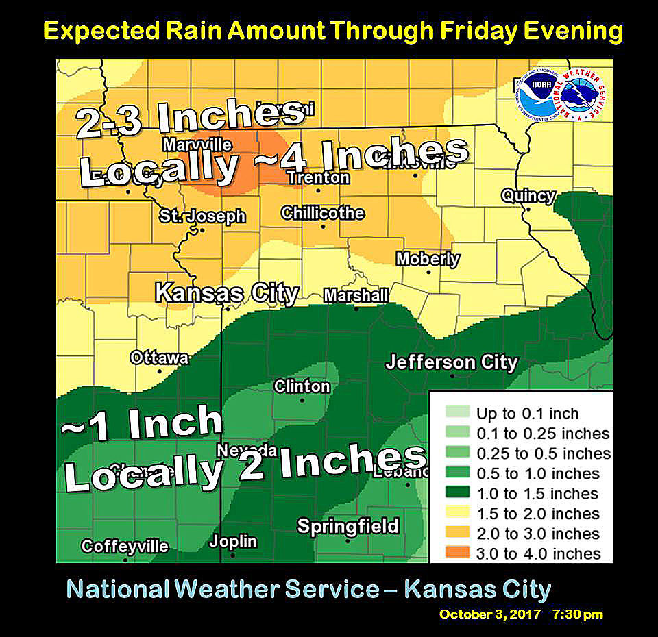
GRAPHIC FROM NATIONAL WEATHER SERVICE
This graphic, posted to the National Weather Service – Pleasant Hill Facebook page Tuesday evening, shows the potential for rainfall totals in northwestern Missouri through Friday evening. Rainfall totals could add up to around 4 inches locally as a warm front stalls over the Iowa border.
Monday’s heat was just the beginning of a week of abnormal early fall weather.
The National Weather Service office in Pleasant Hill is reporting that northwestern Missouri could be in for up to 4 inches of rain from tonight through Saturday morning.
Staff meteorologist Jimmy Barham said this much rain in the early fall was abnormal.
“We don’t usually have the conditions to get that much rain, but we’ve got enough moisture coming up from the Gulf (of Mexico) to come in and give us this kind of rainfall,” Barham said.
The system started as a cold front stalled just south of the Kansas City metro area, then it moved north. From Thursday night to Friday night and into Saturday morning, the system is expected to stall over the Missouri-Iowa border as a warm front.
Barham said the stalled system should bring plenty of rain.
“The frontal boundary will stall over the Iowa border for about 24 to 48 hours, resulting in continual storms that will form and pass through the area,” Barham said. “We’re looking at about five to six major storms, each one bringing anywhere from one-half to 1 inch of rain.
“A majority of the strongest storms occur overnight, when we’ll get a low-level jet stream that adds to the intensity of the storms. Most of the heavy rain periods will take place after the sun sets.”
While the storms will be efficient rain-makers, Barham said the likelihood for severe storms is low.
“When we get heavy rain, there usually isn’t as much severe weather because there’s too much moisture to produce the necessary energy for a severe storm,” Barham said. “With thunderstorms, lightning is always a threat, but the hail threat will be fairly low, the tornado threat is almost nothing, and strong winds are also not going to be a threat.
“What we’re really looking at is heavy thunderstorms, and the worry is that as the storms re-form and move over the same area multiple times, we may get high precipitation amounts over that time period.”
On Wednesday afternoon, the National Weather Service issued a Flood Watch for the region that will last from Thursday at 7 p.m. to Saturday at 7 a.m. Barham said in those events, roads that are commonly washed out will likely be closed for awhile, but some other roads may be washed out as well.
“If it’s raining hard and you’re having trouble seeing, you have a chance to get caught in high water on the road,” Barham said. “Be sure to take more precautions and have your headlights on as you drive.”
At the same time, however, what makes rural Missouri unique from urban Missouri during heavy rain events is that flooding looks different. Barham said that while similar events flooded areas of downtown St. Louis and Kansas City over the summer, northern Missouri is more at risk for oversaturated fields.
“There are multiple natural areas for water to go in rural Missouri,” Barham said. “Water can’t go through concrete, so in Kansas City, if it has nowhere to go, it will stand and collect for awhile.
“During heavy rain events in northwest Missouri, the likelihood is more that the intense storms will produce areal flooding in valleys, creek beds and fields, where it lasts for a bit and then flows away within a few hours. It really comes down to the fact that the ground is different there.”
Barham said it is important to be weather aware, especially into the overnight hours, as this system moves through the area. The Missouri Department of Transportation also encourages taking more precautions when the potential for flooding exists when driving, and that it’s always best to “Turn Around, Don’t Drown.”