‘Honey War’ project brings history close to home
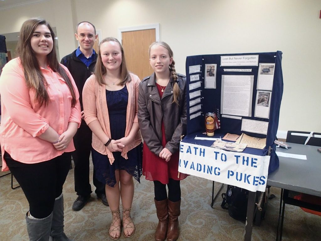
TONY BROWN/DAILY FORUM
North Nodaway High School students and their teacher, Ryan Young, pose beside a display about the “Honey War,” an 1830s border dispute between Missouri and Iowa. Students pictured from left include Leslie Richardson, Makayla Cross, and Emily Dew.
Most people in these parts think of American history as something that happened a long way away from wherever they happen to be.
The great events that shaped the nation, so it seems at first glance, took place many miles from Nodaway County — within the marble halls of the Capitol in Washington, D.C., for example, or on faraway battlefields with names like Yorktown and Gettysburg.
But in truth, the strands of history can be picked up and followed almost anywhere. You just have to know where and how to look.
That’s what a trio of North Nodaway High School sophomores recently discovered when looking for a topic around which to build a display for this year’s regional National History Day competition, which took place Friday at Northwest Missouri State University.
In addition to the North Nodaway team of Leslie Richardson, Makayla Cross, and Emily Dew, this year’s contest attracted more than 160 middle- and high-school students from nine districts in three counties.
Competing in both individual and team formats, the students presented research on dozens of historical events and personalities using stationary exhibits, theatrical dramatizations, video documentaries, websites, and traditional academic papers.
Richardson, Cross, and Dew’s booth presented photographs and articles relating to a little known, and somewhat bizarre, episode of Missouri-Iowa history known as the Honey War.
The “war” itself, which thankfully produced no casualties, took place in 1839 somewhere north of Clark County, Missouri, in what was then the extreme southeast corner of the Iowa Territory.
Opposing militias were ranged across a 10-mile-wide strip of land extending the width of both states that Missouri Gov. Lilburn Boggs had decided belonged to Missouri. Boggs’ determination was based on an ambiguous survey description that confused rapids on the Des Moines River with the Des Moines Rapids on the Mississippi River.
What the North Nodaway team discovered during the course of their research was that the flawed survey, conducted in 1816 by John C. Sullivan, began tracing the straight-line boundary between the two states near Sheridan, a small Worth County community just east of Hopkins.
The east-west portion of the survey began in Worth County because, until the Platte Purchase of 1836, Sheridan was as far west as northwest Missouri went. Everything else was still “Indian Territory.”
Stone markers delineating the disputed boundary, known as the Sullivan Line, still exist in Worth County, and the Hopkins students traveled there and photographed them for their exhibit.
So even though the Honey War confrontation occurred on the other side of the state, the disputed border that caused all the trouble began just a few miles from the classroom where Richardson, Cross, and Dew study history five days a week with their teacher, Ryan Young.
As for the “war,” it all started in 1839 when a Missouri tax collector cut down trees containing honey bee hives in lieu of collecting taxes supposedly owed to the state by Iowa Territory residents living in the disputed strip. As a result, the Clark County, Missouri, sheriff was arrested by the Van Buren County, Iowa sheriff.
Boggs — not one of the more emotionally stable politicians in Missouri history — called out the militia. Iowa responded in kind, and soon the two “armies” were jostling against each other somewhere around wherever the border was supposed to be.
One of the things that most impressed the Hopkins students was the assortment of weapons the opposing camps intended to use on one another.
One “soldier” apparently intended to attack the enemy with a sausage grinder. Another wielded a plow coulter, a knife-like implement used to break up the soil in advance of a mule-drawn plow.
Arsenals on both sides also included an assortment of blunderbusses, flintlocks, and homemade swords.
Within the Iowa ranks, the Hopkins team found, militiamen came up with a catchy rallying cry: “Death to the invading pukes.” Pukes in that day was a nickname for anyone from Missouri. And yes, the word in 1839 meant about the same thing it means today.
Fortunately, cooler heads prevailed. Just as it appeared violence was inevitable, politicians working behind the scenes managed to get the issue submitted to Congress while convincing Boggs and Iowa territorial authorities to suspend hostilities.
Also, it was the middle of winter, and on the “front lines” food — and probably liquor — were starting to run short.
The Supreme Court finally settled the dispute in 1851 and established the Sullivan Line as the official northern boundary of the State of Missouri.
However, questions persisted for more than 150 years, and in 2005 Missouri had the border resurveyed, at which time many of the stone markers installed during a Supreme Court-ordered survey in 1850 were uncovered.
“There was no bloodshed,” Cross said, “No one died. So it wasn’t really a war. It was more of a heated discussion.”
Young, the team’s instructor, said he was impressed with the girls’ efforts, adding that what the group learned about the “process of research” was at least as valuable as acquiring knowledge related to an obscure episode in the history of pre-Civil War Missouri.
“Ninety percent of it was them,” Young said. “All I told them was that National History Day is March 3, and they ran with it. I’m very satisfied with the result. There is a lot of pride here.”