Motorists rescued as storm sweeps over region
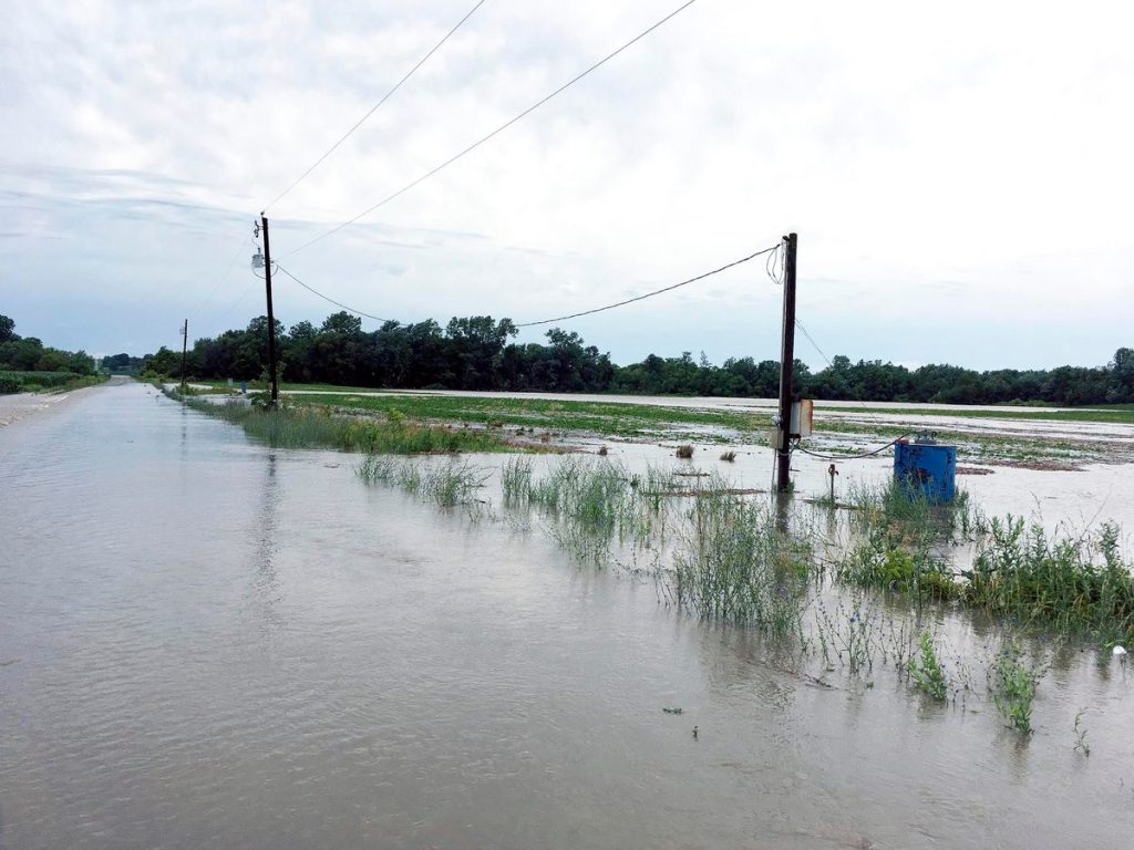
KAITY HOLTMAN/DAILY FORUM
The flooded Platte River is shown running across 310th Street west of Conception Junction following Wednesday night’s severe summer storm. No severe injuries were reported, and damage to structures was limited to some flooded basements. However, high water stranded at least two motorists, one in Nodaway County and one in Gentry County, who had to be rescued by teams of first responders.
Nodaway County more or less dodged the bullet during a major summer storm overnight Wednesday that produced tornadoes, heavy rain, flash flooding, some crop damage and severe lightning across the region.
There was one very close call, however, as multiple first-responder agencies worked well past midnight to rescue a motorist stranded in fast-moving floodwater after attempting to drive a pickup truck across the White Cloud Creek bridge on 250th Street just west of Maryville.
Sheriff Randy Strong said a nearby resident returning home from his swing-shift job heard the man yelling while clinging to his truck, which was nearly submerged in the rushing water.
Strong said the resident, who immediately called authorities, said the man’s head was visible above the torrent but little else.
Deputies responded, as did Maryville Public Safety Officers Aaron Jones and Tyler Salsbury.
Jones and Salsbury, who are assigned to the Mozingo Lake Recreation Park water patrol, brought a jet ski with them that was used to effect the rescue, Strong said.
Also summoned to the scene were members of the Clarinda, Iowa-based Midwest Regional Dive Team.
Strong said Salsbury and Jones used the Jet Ski to reach the struggling motorist, who was able to clamber aboard a basket-like flotation device, which was then towed to shore.
The motorist, whose name was not immediately available, was taken to St. Francis Hospital in Maryville but reportedly survived the ordeal without significant injuries.
In a second incident, Strong said a deputy working as a storm spotter was shaken up while standing outside his vehicle when lightning struck nearby.
Another officer, who was sitting inside the vehicle, said he saw his partner’s hair stand on end, and the deputy himself said later he felt his muscles seize up as he fell back onto the car. He compared the experience to being shot with a Taser during a training exercise.
Strong said the deputy appeared to recover after a few moments and was found to be uninjured after being checked out by a physician.
A second deputy, the sheriff said, was nearly washed off a rural road when he failed to see water rushing over a bridge. The patrol vehicle began to float, Strong said, but then regained traction, allowing the officer to proceed on his way.
By all accounts it was a long and dangerous night, and Strong said one of the more bizarre reports described cattle being washed across Highway 136 at the Long Branch bridge just east of Mozingo Lake.
Flooded roads were also reported at Highway 46 where it crosses White Cloud Creek near Hallmark Road, at Route U near Arkoe, Route V at White Cloud Creek near Hawk Road southwest of Maryville and Route NN at the Platte River northwest of Parnell.
Law enforcement received numerous reports of tornadoes and tornadic rotation across the northern and central parts of the county, and storm sirens in Maryville and surrounding communities sounded several times during the night beginning around 5:30 p.m., when rotation was reported near Mozingo Lake Recreation Park.
In addition, Strong said there were multiple confirmed sightings of a tornado about five miles south of Maryville moving southeastward toward the Tri-C area of Conception Junction, Conception and Clyde.
Strong, who was among those to see the tornado, said he was unsure if the twister ever touched the ground. There were no reports of major property damage or injuries.
County Emergency Management Director Christy Forney said she received a single citizen report, unconfirmed, stating that the twister did in fact touch down.
Forney said her best guess at the tornado’s size was EF-0, the lowest intensity rating on a six-step scale indicating rotating winds of between 65 and 85 mph. That estimate has not been confirmed.
She said damage reports around the county were limited to a few downed trees, water-covered roads and bridges and flooded basements.
On average, approximately 7 inches of rain fell across Nodaway County Wednesday night beginning around 6 p.m. However, Forney said some areas experienced downpours of 10 inches or more.
The National Weather Service released a series of nearly a dozen tornado and severe thunderstorm warnings throughout the night, with rainfall continuing in some locations until past sunrise Thursday.
Forney said there were several reports early on of what appeared to be tornadic rotation in the north part of the county along the Iowa border, and that funnel clouds were also observed to the east in Worth and Gentry counties in Missouri.
She said first-responders rescued a second motorist stranded by floodwater Thursday morning in Gentry County during an operation that resembled the episode in Nodaway County only a few hours before.
With more rain in the forecast, and streams and rivers either bank-full or at flood stage, Forney urged motorists to avoid moving water at all costs.
“Do not drive through water,” she said. “This water is deep, and now that the ground is saturated, we’re going to have more of the same.”
The real damage Wednesday night occurred north of the Iowa Line, where, according to the Associated Press, a tornado touched down in Fremont County between Sidney and Shenandoah, flattening crops and damaging structures.
A home near Farragut, Iowa, was damaged, but no injuries were reported.
Structure damage was also reported in or near the Iowa community of Bedford about a half-hour north of Maryville.