El Niño brings wet December to Nodaway
PHIL COBB/DAILY FORUM
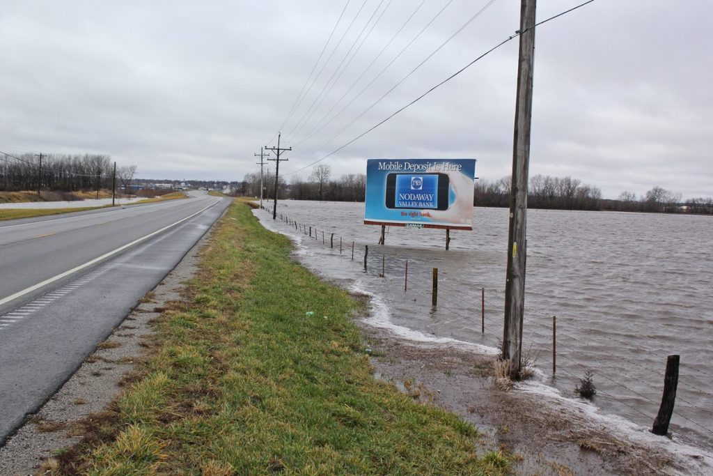
The One Hundred and Two River east of Maryville was well over its banks Monday following a weekend of rain that ended after becoming mixed with a brief snow flurry Monday morning. Route U between Arkoe and Keystone Road was closed due to flooding on Monday, as was Highway 49 between Route PP and Highway 113.
The El Niño of 2015 is an abnormally strong event, reportedly one of the three strongest since 1950, and the weather pattern across northwest Missouri is proof positive of that.
“The El Niño means warmer and wetter weather, and so far that’s how this year is playing out,” said Jeff Bradley, senior instructor of climatology at Northwest Missouri State University.
In simpler terms, “It’s wet is what it is,” Nodaway County Farm Service Agency director Tim Dreier said Monday.
With 2.26 inches of rainfall recorded at the FSA office on East South Hills Drive over Saturday and Sunday, the annual precipitation accumulation for December is at 2.66 inches, compared to the 30-year monthly average of just 1.4 inches.
With a near record of 13.96 inches of rainfall during July playing a major role, the year-to-date accumulation for the Maryville reporting station is 50.02 inches, far in excess of the 35.05-inch average since 1918.
Pushed by the local record rainfall of 62.59 inches in July 1993 and more than 40 inches in 2014, 2009, 2007, 1992, and 1986, the 30-year annual average for rainfall in Maryville is 35.65 inches.
“Especially in the Midwest, the Northeast, and really most of the eastern United States, we are under the continuing effect of an El Niño,” Bradley said Monday. “And the one in progress now is actually a pretty strong one.”
A so-called El Niño results from above-average warming in the equatorial Pacific Ocean along the coast of South America that causes a shift in climate patterns worldwide. The name actually refers to the Christ child because the phenomenon often occurs around Christmas.
“The wet weather over the past weekend was not too different from a similar pattern we had some two weeks ago,” Bradley said. “This is a little unusual, and the pattern is having the effect of making the year wetter.”
Both Bradley and Dreier noted that very wet weather through much of the summer, coupled with an unusually dry autumn, was non-typical as well.
“Our fall has been really dry so far, but we are starting to feel the effects of El Niño now, and we probably will for the next few weeks,” Bradley said.
“We really have a sort of a roller coaster. We average about 34 to 36 inches of precipitation a year, and while we are certainly above that this year, next year may be below that.”
Bradley used the example of the 2007 NCAA Division II semifinals football game when Northwest hosted Grand Valley State in 14-degree weather and freezing drizzle.
“It had been cold for several weeks, and Colden Pond was frozen solid — solid enough that it supported a couple of hundred students trying to punch a hole in the ice with the goalpost they had torn down after the Northwest victory,” Bradley remembered.
“That same year, we had more than four and half feet of snow, and the next year, 2008-09, there was no snow.”
Such weather variations are not unusual, he said.
“You have to go back maybe 100 years to see a ‘trend,’” Bradley said. “Considering how this Earth is, even that’s just a little bump. To get a ‘real’ trend takes thousands of years. I’d think Earth is just going through a normal routine.”
The weekend’s steady rainfall Saturday night and through much of Sunday resulted in some local flooding.
The One Hundred and Two River east of Maryville was running well over bank full Monday, inundating low-lying fields.
High water resulted in the closure of Route U between Arkoe and Keystone Road, according to the Missouri Department of Transportation, and Highway 49 between Route PP and Highway 113 was also closed due to flooding along the Nodaway River.
The extended forecast for the Maryville area calls for continued unseasonably warm weather during the next two weeks with temperatures in the low 50s Sunday through Tuesday. Forecasters are also calling for slight chances of rain from Sunday through Christmas week.