Pilotless craft used to gather data on crops
By KAITY HOLTMAN Agriculture editor
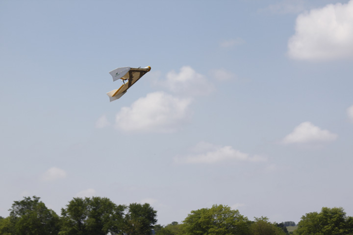
The AgEagle Unmanned Aerial System flies 220-foot swaths over a cornfield to capture images of crop conditions from a 400-foot-high perspective. This allows producers to assess their next steps in treating problem areas in each field.
Technology has always been a driving force in agriculture. Now, as a recent demonstration of an Unmanned Aerial System (UAS) showed, it is a flying force as well.
Last Thursday, a handful of farmers and seed professionals gathered south of Maitland to watch an AgEagle crop scouting demonstration.
Eric Godwin, a data technician for precision agriculture company Prime Meridian, flew the AgEagle UAS over Milne Farms’ 155-acre cornfield. Erin Dinsdale, agronomist and part owner of Milne-Dinsdale Seed, coordinated the event.
Using software on his laptop, Casey Alden, another Prime Meridian technician, set up a flight pattern, stitching imagery and boundary box right there in the field. He gave the aircraft a starting point and told it exactly where to land.
He set the flight path against the wind to provide more consistent images — near-infrared photos gathered using a Canon S100 camera.
The images, which show plant coloration, low growth areas, weed patches and density, are used to evaluate crop conditions in relation to a Normalized Difference Vegetation Index, or NDVI. The higher the index number, the better the crop.
UAS technology allows the craft to send images back to the computer as it flies. In Godwins flights so far this year, they’ve been able to capture herbicide damage, poor stands and low population.
“The image consistency does depend on the weather conditions, the clouds and wind,” Godwin said. “We get the best results if it’s completely overcast or there are no clouds.”
On the day of the demonstration, the clouds were spotty, which meant the coloration of the images varied a little in shaded areas.
“Right now we’re doing a lot of flying to derive data and make nitrogen recommendations to growers,” Godwin said. “At post-tassel time, we’ll be flying to guestimate yield possibilities.”
Godwin said this is a learning year.
“There are a few brands of (aircraft) out there,” he said. “We chose AgEagle because our company is based out of Nevada, Missouri, and AgEagle is in Nevada’s backyard, in Neodesha, Kansas. We’re learning what it can do, what’s out of range, and so on.”
The craft used in the demonstration logged images once per second while flying 220-foot swaths over the field. It then doubled back to overlap 110 feet. The camera angle was set at 55 degrees, creating a 300 percent overlap to make sure everything was fully captured.
“The AgEagle can cover an 80-acre field in 11 minutes,” Godwin said. “Right now we’re comfortable with having it up for 35 minutes, which is about 200 acres, before we swap batteries. They’re working on a larger battery, and we’re hoping for about 55 minutes consistent fly-time.”
Godwin said he can do multiple adjoining fields and split them up on the laptop afterwards.
Dinsdale stressed that pilotless craft are a tool growers can use to maximize yields, but that farmers shouldn’t rely on flight images alone when making decisions.
“This is one tool of many to increase efficiency,” Dinsdale said. “Seeing inconsistencies probably tells them to call their agronomist and helps them make decisions about which spots to pay extra attention to and help along.”
She said she uses a hand-held Green Seeker to do spot-checking.
“With this, we can go straight to the problem areas,” she said. “We can make the slowest dog faster, to catch up with the rest of the pack.”
Godwin said it’s important for anyone flying the AgEagle, be they a farmer or dealer, to follow the rules carefully.
“We work to make sure we are courteous to surroundings and others in the area, especially crop dusters,” Godwin said. “This is really in the beginning stages, and we want to make sure we’re doing everything right, because this is an opportunity that we don’t want to lose.”
Godwin said the technology is constantly evolving and not yet perfected.
“It is always changing and becoming more current,” he said. “It’s been a whirlwind.”
Issues include software bugs, consistency among operators, obstacles and weather interference, and the fact that the plane is fully automated and can’t be flown manually.
But the machines are becoming more user-friendly, which is making them attractive for producers.
“We at Prime Meridian are dealers, and we’ve got an AgEagle package starting at $16,000, which includes the bird, the laptop and software, insurance, and 500 acres of processing,” Godwin said.
But that’s a price tag not every producer can afford. Godwin said the company also offers promotional testing for growers who don’t want to operate the craft themselves.
“This year, we’ve got a $2-per-acre rate for promotional flights if growers are interested,” he said. “For more pricing info, they can definitely reach out to us at Prime Meridian, and we’ll work something out.”
Dinsdale is glad that Nodaway County producers were able to see this demonstration.
“This is new, cutting-edge technology, but looking 5-10 years into the future this will be much more common,” Dinsdale said. “We’re all embarking on a new journey, but it will move quickly, and it’s great that Nodaway County can be a part of that.”